


YGDH - Gunnedah
Located in Gunnedah, Australia
ICAO - YGDH, IATA - GUH
Data provided by AirmateGeneral information
Coordinates: S30°57'40" E150°15'2"
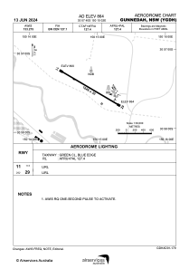
Elevation is 863 feet MSL.
View others Airports in New South Wales
Operational data
Special qualification required
Current time UTC:
Current local time:
Weather at : YSTW - Tamworth ( 58 km )
METAR: YSTW 102000Z AUTO 15004KT 9999 -SHRA SCT076 BKN089 OVC105 13/12 Q1025
TAF: TAF AMD YSTW 101644Z 1018/1112 13006KT 9999 -RA FEW010 SCT050 FM110300 13006KT 9999 -SHRA BKN030 TEMPO 1018/1103 4000 RA SCT005 BKN050 INTER 1103/1112 3000 SHRA SCT005 BKN020
Communications frequencies: [VIEW]
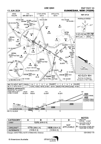
Runways:
| RWY identifier | QFU | Length (ft) | Width (ft) | Surface | LDA (ft) |
| 17 | 183° | 1942 | 98 | GRS | |
| 35 | 3° | 1942 | 98 | GRS | |
| 11 | 123° | 5400 | 98 | ASP | |
| 29 | 303° | 5400 | 98 | ASP |
Airport contact information
Address: Gunnedah Australia
