


WIJI - Kerinci/Depati Parbo
Located in , Indonesia
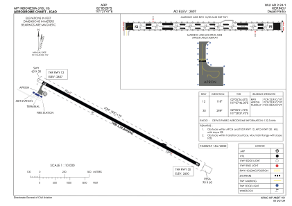
ICAO - , IATA - KRC
Data provided by AirmateGeneral information
Coordinates: S2°5'28" E101°27'47"
Elevation is 2607 feet MSL.
View others Airports in Jambi
Operational data
Special qualification required
Current time UTC:
Current local time:
Weather at : - ( 0 km )
METAR: PAII 211709Z AUTO 25007KT 10SM -RA FEW008 BKN028 OVC033 04/03 A2975 RMK AO2 P0000
Communications frequencies: [VIEW]
Runways:
| RWY identifier | QFU | Length (ft) | Width (ft) | Surface | LDA (ft) |
| 12 | 118° | 5906 | 98 | UNK | |
| 30 | 298° | 5906 | 98 | UNK |
Airport contact information
Address: Indonesia