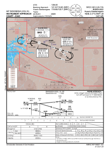
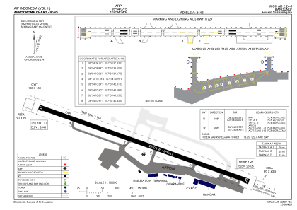


WICC - Bandung/Husein Sastranegara
Located in Bandung, Indonesia
ICAO - WICC, IATA - BDO
Data provided by AirmateGeneral information
Coordinates: S6°54'7" E107°34'34"
Elevation is 2445 feet MSL.
View others Airports in Jawa Barat
Operational data
Special qualification required
Current time UTC:
Current local time:
Weather at : - ( 0 km )
METAR: CYUX 280341Z AUTO 10010G22KT 340V110 1SM -SN SCT007 BKN010 OVC019 M05/M06 A2918 RMK SLP883
Communications frequencies: [VIEW]
Runways:
| RWY identifier | QFU | Length (ft) | Width (ft) | Surface | LDA (ft) |
| 11 | 109° | 7283 | 148 | ASP | |
| 29 | 289° | 7283 | 148 | ASP |
Airport contact information
Address: Bandung Indonesia