


WATT - Kupang/El Tari
Located in West Kupang, Indonesia
ICAO - WATT, IATA - KOE
Data provided by AirmateGeneral information
Coordinates: S10°10'40" E123°39'50"
Elevation is 345 feet MSL.
View others Airports in Nusa Tenggara Timur
Operational data
Special qualification required
Current time UTC:
Current local time:
Weather
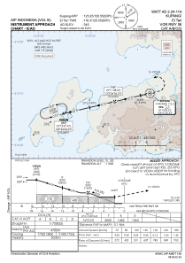
TAF: TAF WATT 062300Z 0700/0724 11012KT 9999 SCT017 PROB40 TEMPO 0703/0707 11014G24KT
Communications frequencies: [VIEW]
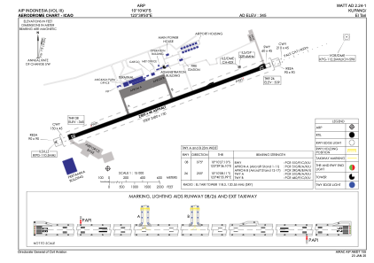
Runways:
| RWY identifier | QFU | Length (ft) | Width (ft) | Surface | LDA (ft) |
| 07 | 77° | 8202 | 148 | ASP | |
| 25 | 257° | 8202 | 148 | ASP | |
| 08 | 0° | 8202 | 148 | UNK | |
| 26 | 0° | 8202 | 148 | UNK |
Airport contact information
Address: West Kupang Indonesia