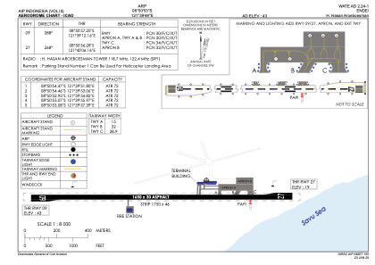


WATE - Ende / H. Hasan Aroeboesman
Located in Ende, Indonesia
ICAO - WATE, IATA - ENE
Data provided by AirmateGeneral information
Coordinates: S8°50'53" E121°39'48"
Elevation is 43 feet MSL.
View others Airports in Nusa Tenggara Timur
Operational data
Special qualification required
Current time UTC:
Current local time:
Weather at : - ( 0 km )
METAR: CYHD 292251Z AUTO 06009KT 2 1/2SM -SN -UP BKN008 BKN012 OVC018 00/M00 A2981 RMK SLP118
Communications frequencies: [VIEW]
Runways:
| RWY identifier | QFU | Length (ft) | Width (ft) | Surface | LDA (ft) |
| 09 | 89° | 5413 | 98 | ASP | |
| 27 | 269° | 5413 | 98 | ASP |
Airport contact information
Address: Ende Indonesia