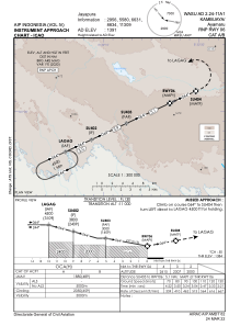
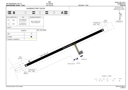


WASU - Kambuaya/Ayamaru
Located in Ayamaru, Indonesia
ICAO - , IATA - KBX
Data provided by AirmateGeneral information
Coordinates: S1°19'6" E132°16'57"
Elevation is 1391 feet MSL.
Magnetic variation is 1° East View others Airports in Irian Jaya
Operational data
Special qualification required
Current time UTC:
Current local time:
Weather at : - ( 0 km )
METAR: PFKW 151603Z AUTO 17024G31KT 10SM BKN024 OVC032 03/M01 A2967 RMK AO2 PK WND 16030/1600
Communications frequencies: [VIEW]
Runways:
| RWY identifier | QFU | Length (ft) | Width (ft) | Surface | LDA (ft) |
| 06 | 65° | 3937 | 98 | UNK | |
| 24 | 245° | 3937 | 98 | UNK |
Airport contact information
Address: Ayamaru Indonesia