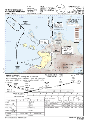
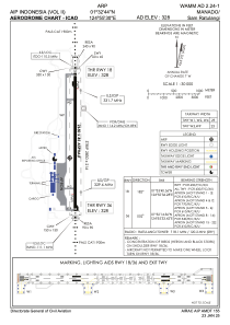


WAMM - Manado/Sam Ratulangi
Located in Manado, Indonesia
ICAO - WAMM, IATA - MDC
Data provided by AirmateGeneral information
Coordinates: N1°32'44" E124°55'30"
Elevation is 328 feet MSL.
View others Airports in Sulawesi Utara
Operational data
Special qualification required
Current time UTC:
Current local time:
Weather
METAR: WAMM 291630Z 32003KT 9999 SCT019 25/25 Q1008 NOSIG
TAF: TAF WAMM 291100Z 2912/3018 VRB02KT 9000 SCT019 PROB40 TEMPO 2914/2918 5000 RA FEW017CB BECMG 3001/3002 06010KT
Communications frequencies: [VIEW]
Runways:
| RWY identifier | QFU | Length (ft) | Width (ft) | Surface | LDA (ft) |
| 18 | 182° | 8694 | 148 | ASP | |
| 36 | 2° | 8694 | 148 | ASP |
Airport contact information
Address: Manado Indonesia