


W20 - Moses Lake Muni
Located in Moses Lake, United States
ICAO - W20, IATA -
Data provided by AirmateGeneral information
Coordinates: N47°8'31" W119°14'16"
Elevation is 1205 feet MSL.
Magnetic variation is 19° East View others Airports in Washington
Operational data
Special qualification required
Current time UTC:
Current local time:
Weather at : KMWH - Grant County Intl ( 10 km )
METAR: KMWH 211552Z 25005KT 10SM CLR 16/04 A3000 RMK AO2 SLP159 T01560039
TAF: KMWH 211128Z 2112/2212 23005KT P6SM SKC FM211500 20007KT P6SM BKN120 FM212000 22010G17KT P6SM -RA OVC080 FM220200 22011KT P6SM OVC060 PROB30 2202/2206 6SM -RA BR FM220600 20009KT P6SM OVC060 PROB30 2210/2212 -SHRA OVC025
Communications frequencies: [VIEW]
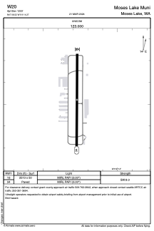
Runways:
| RWY identifier | QFU | Length (ft) | Width (ft) | Surface | LDA (ft) |
| 16 | 0° | 2513 | 50 | ASPH | |
| 34 | 0° | 2513 | 50 | ASPH |
Airport contact information
Address: Moses Lake United States
