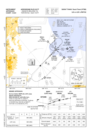
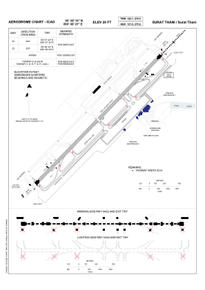


VTSB - Surat Thani / Surat Thani Airport
Located in Surat Thani, Thailand
ICAO - VTSB, IATA - URT
Data provided by AirmateGeneral information
Coordinates: N9°8'10" E99°8'21"
Elevation is 20 feet MSL.
View others Airports in Surat Thani Province
Operational data
Special qualification required
Current time UTC:
Current local time:
Weather
METAR: VTSB 041200Z 19006KT 9999 FEW020 29/25 Q1006 NOSIG
TAF: TAF VTSB 041100Z 0412/0512 34003KT 9999 FEW020 BKN100 BECMG 0504/0506 05008KT TEMPO 0507/0512 VRB15G25KT 4000 TSRA FEW016CB SCT018 BKN100
Communications frequencies: [VIEW]
Runways:
| RWY identifier | QFU | Length (ft) | Width (ft) | Surface | LDA (ft) |
| 04 | 44° | 9842 | 148 | ASP | |
| 22 | 224° | 9842 | 148 | ASP |
Airport contact information
Address: Surat Thani Thailand