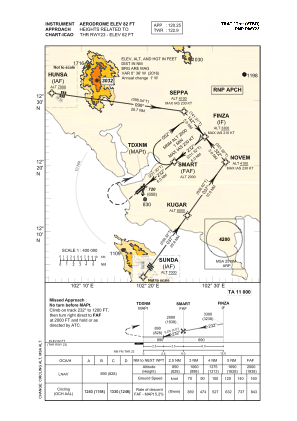


VTBO - Trat (Khao Sming) / Trat Airport
Located in Trat, Thailand
ICAO - VTBO, IATA - TDX
Data provided by AirmateGeneral information
Coordinates: N12°16'31" E102°19'12"
Elevation is 82 feet MSL.
View others Airports in Trat Province
Operational data
Special qualification required
Current time UTC:
Current local time:
Weather
TAF: TAF VTBO 051100Z 0512/0612 22008KT 9000 FEW020 SCT100 BECMG 0521/0523 10005KT 4000 BR BECMG 0601/0603 23008KT 9000 NSW TEMPO 0607/0611 VRB15KT 4000 TSRA FEW018CB SCT035
Communications frequencies: [VIEW]
Runways:
| RWY identifier | QFU | Length (ft) | Width (ft) | Surface | LDA (ft) |
| 05 | 51° | 5906 | 148 | ASP | |
| 23 | 231° | 5906 | 148 | ASP |
Airport contact information
Address: Trat Thailand