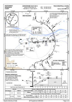
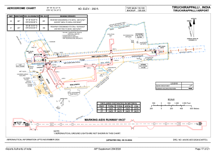


VOTR - Tiruchirappalli Airport, Tiruchirappalli
Located in Tiruchirappalli, India
ICAO - VOTR, IATA - TRZ
Data provided by AirmateGeneral information
Coordinates: N10°45'56" E78°42'54"
Elevation is 290 feet MSL.
View others Airports in Tamil Nadu
Operational data
Special qualification required
Current time UTC:
Current local time:
Weather
METAR: VOTR 291300Z 25009KT 6000 FEW016 36/25 Q1002 NOSIG
TAF: TAF VOTR 291100Z 2912/3018 27010KT 5000 HZ FEW016 SCT100 TEMPO 2912/2918 27015G25KT 3000 TSRA/RA FEW016 FEW025TCU/CB BKN080 BECMG 2918/2919 27015KT BECMG 3006/3007 6000 BECMG 3012/3013 5000 HZ
Communications frequencies: [VIEW]
Runways:
| RWY identifier | QFU | Length (ft) | Width (ft) | Surface | LDA (ft) |
| 09 | 85° | 7949 | 148 | ASP | |
| 27 | 265° | 7949 | 148 | ASP |
Airport contact information
Address: Tiruchirappalli India