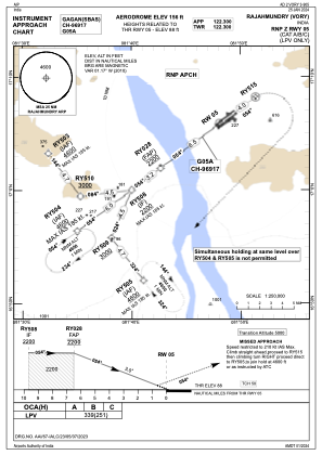
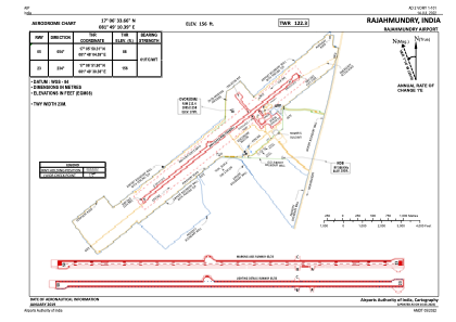


VORY - Rajahmundry Airport
Located in Rajahmundry, India
ICAO - VORY, IATA - RJA
Data provided by AirmateGeneral information
Coordinates: N17°6'34" E81°49'10"
Elevation is 151 feet MSL.
View others Airports in Andhra Pradesh
Operational data
Special qualification required
Current time UTC:
Current local time:
Weather
METAR: VORY 290900Z 24010KT 6000 FEW020 39/22 Q1006 NOSIG
TAF: TAF VORY 290800Z 2909/2918 23010KT 6000 FEW015 SCT025 TEMPO 2910/2915
Communications frequencies: [VIEW]
Runways:
| RWY identifier | QFU | Length (ft) | Width (ft) | Surface | LDA (ft) |
| 05 | 53° | 10384 | 148 | ASP | |
| 23 | 233° | 10384 | 148 | ASP |
Airport contact information
Address: Rajahmundry India