


VOAT - Agatti Airport, Agatti
Located in Agatti, India
ICAO - VOAT, IATA - AGX
Data provided by AirmateGeneral information
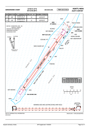
Coordinates: N10°49'27" E72°10'36"
Elevation is 14 feet MSL.
View others Airports in Lakshadweep
Operational data
Special qualification required
Current time UTC:
Current local time:
Weather
METAR: VOAT 170500Z 31008KT 5000 HZ SCT015 32/26 Q1009 NOSIG
TAF: TAF VOAT 170200Z 1703/1712 04010KT 5000 BR FEW012 SCT080 BECMG 1703/1705 35005KT 6000 FEW015 FEW025TCU SCT080 TEMPO 1709/1712 26010KT 3000 TSRA SCT012 FEW025CB BKN080
Communications frequencies: [VIEW]
Runways:
| RWY identifier | QFU | Length (ft) | Width (ft) | Surface | LDA (ft) |
| 04 | 35° | 3950 | 98 | ASP | |
| 22 | 215° | 3950 | 98 | ASP |
Airport contact information
Address: Agatti India