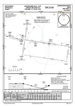


VEDH - Darbhanga
Located in DARBHANGA, India
ICAO - , IATA - DBR
Data provided by AirmateGeneral information
Coordinates: N26°11'39" E85°54'55"
Elevation is 154 feet MSL.
View others Airports in Bihar
Operational data
Special qualification required
Current time UTC:
Current local time:
Weather at : - ( 0 km )
METAR: CYAT 192104Z AUTO 23008G16KT 9SM BKN076 BKN091 BKN110 15/12 A2957 RMK SLP015 DENSITY ALT 500FT
Communications frequencies: [VIEW]
Runways:
| RWY identifier | QFU | Length (ft) | Width (ft) | Surface | LDA (ft) |
| 10 | 0° | 8999 | 150 | UNK | |
| 28 | 0° | 8999 | 150 | UNK |
Airport contact information
Address: DARBHANGA India