


VANP - Dr Babasaheb Ambedkar International Airport , Nagpur
Located in Nagpur, India
ICAO - VANP, IATA - NAG
Data provided by AirmateGeneral information
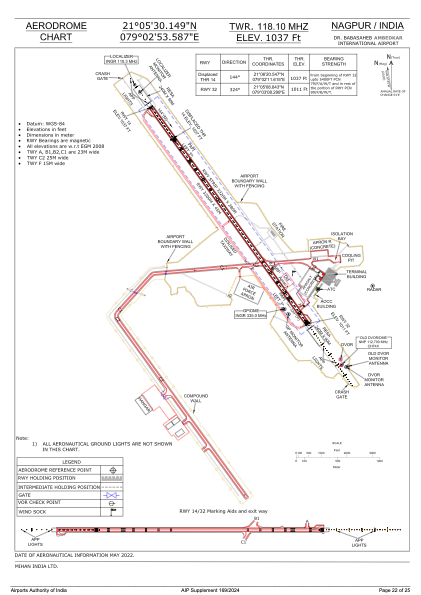
Coordinates: N21°5'30" E79°2'54"
Elevation is 1033 feet MSL.
View others Airports in Maharashtra
Operational data
Special qualification required
Current time UTC:
Current local time:
Weather
METAR: VANP 220500Z 19007KT 5000 HZ NSC 35/26 Q1007 NOSIG
TAF: TAF VANP 220500Z 2206/2312 14005KT 5000 HZ NSC TEMPO 2211/2215 VRB10KT 4000 -TS/HZ SCT020 FEW030CB BECMG 2216/2218 16003KT 3000 HZ FEW100 BECMG 2303/2305 14003KT 4000 HZ NSC BECMG 2307/2309 16005KT 5000 HZ SCT025
Communications frequencies: [VIEW]
Runways:
| RWY identifier | QFU | Length (ft) | Width (ft) | Surface | LDA (ft) |
| 14 | 144° | 10499 | 148 | ASP | |
| 32 | 324° | 10499 | 148 | ASP |
Airport contact information
Address: Nagpur India