


VAID - Devi Ahilya Bai Holkar Airport, Indore
Located in Indore, India
ICAO - VAID, IATA - IDR
Data provided by AirmateGeneral information
Coordinates: N22°43'24" E75°48'20"
Elevation is 1851 feet MSL.
View others Airports in Madhya Pradesh
Operational data
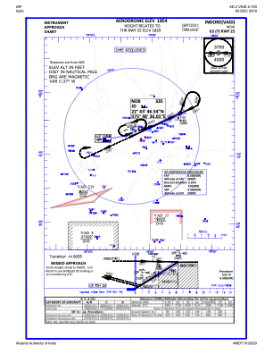
Special qualification required
Current time UTC:
Current local time:
Weather
METAR: VAID 101300Z 02020G30KT 5000 TS HZ FEW020 SCT025 FEW030CB SCT100 37/18 Q1007 TEMPO 4000 -TSRA
TAF: TAF VAID 101100Z 1012/1118 21010KT 6000 FEWW020 SCT025 TEMPO 1012/1016 27015G25KT 4000 -TSRA FEW030CB BECMG 1101/1103 32008KT 5000 HZ FEW02 SCT100 BECMG 1104/1106 34010KT 6000 FEW100
Communications frequencies: [VIEW]
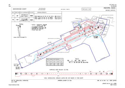
Runways:
| RWY identifier | QFU | Length (ft) | Width (ft) | Surface | LDA (ft) |
| 07 | 65° | 9035 | 148 | COM | |
| 25 | 245° | 9035 | 148 | COM |
Airport contact information
Address: Indore India