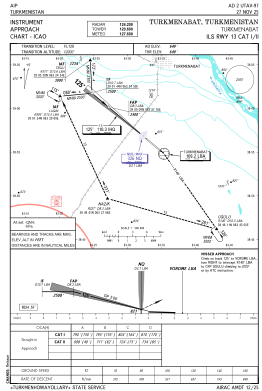
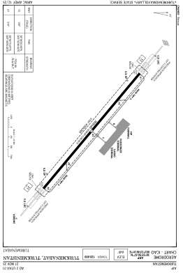


UTAV - Turkmenabat
Located in Turkmenabat, Turkmenistan
ICAO - UTAV, IATA - CRZ
Data provided by AirmateGeneral information
Coordinates: N38°55'51" E63°33'50"
Elevation is 649 feet MSL.
View others Airports in Lebap
Operational data
Special qualification required
Current time UTC:
Current local time:
Weather
METAR: UTAV 022300Z 00000KT CAVOK 20/09 Q1002 R13/CLRD70 NOSIG
TAF: TAF UTAV 022230Z 0300/0324 10016KT 6000 SCT030CB BNK050 TEMPO 0300/0309 16018G28KT 2000 BLDU BKN020 PROB40 TEMPO 0300/0309 VRB32KT -TSRA
Communications frequencies: [VIEW]
Runways:
| RWY identifier | QFU | Length (ft) | Width (ft) | Surface | LDA (ft) |
| 13 | 130° | 12467 | 197 | UNK | |
| 31 | 310° | 12467 | 197 | UNK |
Airport contact information
Address: Turkmenabat Turkmenistan