


UTAM - Mary
Located in Mary, Turkmenistan
ICAO - UTAM, IATA - MYP
Data provided by AirmateGeneral information
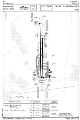
Coordinates: N37°37'18" E61°53'47"
Elevation is 728 feet MSL.
View others Airports in Mary
Operational data
Special qualification required
Current time UTC:
Current local time:
Weather
METAR: UTAM 050900Z 32004KT 9999 BKN026 26/12 Q1011 R88/CLRD70 NOSIG
TAF: TAF UTAM 050440Z 0506/0606 27016KT CAVOK TEMPO 0506/0512 20012G22KT 4000 HZ SCT050 TEMPO 0516/0604 VRB06KT 5000 SCT050
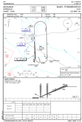
Communications frequencies: [VIEW]
Runways:
| RWY identifier | QFU | Length (ft) | Width (ft) | Surface | LDA (ft) |
| 17L | 179° | 9186 | 148 | UNK | |
| 35R | 359° | 9186 | 148 | UNK | |
| 17R | 179° | 12467 | 148 | UNK | |
| 35L | 359° | 12467 | 148 | UNK |
Airport contact information
Address: Mary Turkmenistan