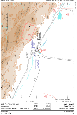
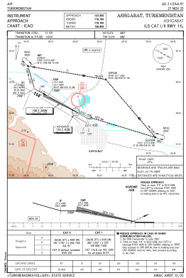
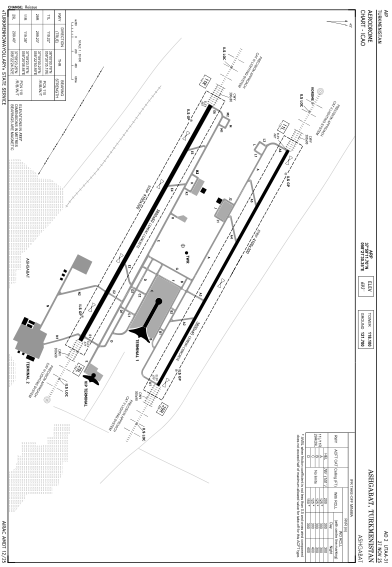


UTAA - Ashgabat
Located in Ashgabat, Turkmenistan
ICAO - UTAA, IATA - ASB
Data provided by AirmateGeneral information
Coordinates: N37°59'12" E58°21'30"
Elevation is 693 feet MSL.
View others Airports in Ahal
Operational data
Special qualification required
Current time UTC:
Current local time:
Weather
METAR: UTAA 290700Z 09004KT 9999 NSC 23/M12 Q1023 R88/70D NOSIG
TAF: TAF UTAA 290449Z 2906/3006 10018KT 6000 SCT050 TEMPO 2909/2914 03016G26KT 4000 DRDU BECMG 2916/2918 16012KT
Communications frequencies: [VIEW]
Runways:
| RWY identifier | QFU | Length (ft) | Width (ft) | Surface | LDA (ft) |
| 11L | 119° | 12467 | 148 | UNK | |
| 29R | 299° | 12467 | 148 | UNK | |
| 11R | 120° | 12467 | 197 | UNK | |
| 29L | 300° | 12467 | 197 | UNK |
Airport contact information
Address: Ashgabat Turkmenistan