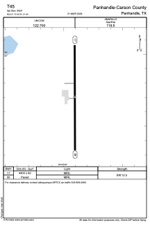


T45 - Panhandle-Carson County
Located in Panhandle, United States
ICAO - T45, IATA -
Data provided by AirmateGeneral information
Coordinates: N35°21'42" W101°21'54"
Elevation is 3454 feet MSL.
Magnetic variation is 08° East View others Airports in Texas
Operational data
Special qualification required
Current time UTC:
Current local time:
Weather at : KAMA - Rick Husband Amarillo Intl ( 35 km )
METAR: KAMA 211853Z 10SM CLR 29/M03 A2982 RMK AO2 SLP041 T02891033 $
TAF: KAMA 211743Z 2118/2218 28015G25KT P6SM SKC FM212200 25014G24KT P6SM SKC FM220400 20008KT P6SM SKC FM220700 35009KT P6SM SCT210 FM221200 03014KT P6SM FEW100
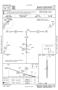
Communications frequencies: [VIEW]
Runways:
| RWY identifier | QFU | Length (ft) | Width (ft) | Surface | LDA (ft) |
| 17 | 180° | 4404 | 60 | ASPH | |
| 35 | 360° | 4404 | 60 | ASPH |
Airport contact information
Address: Panhandle United States