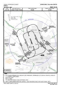
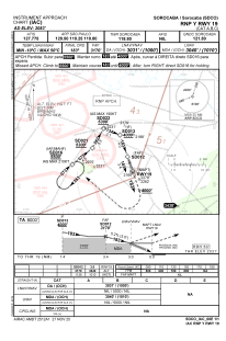


SDCO - Sorocaba
Located in Sorocaba, Brazil
ICAO - SDCO, IATA - SOD
Data provided by AirmateGeneral information
Coordinates: S23°28'40" W47°29'24"
Elevation is 2083 feet MSL.
Magnetic variation is -21.334484324° East View others Airports in São Paulo
Operational data
Special qualification required
Current time UTC:
Current local time:
Weather at : SBKP - Viracopos ( 64 km )
METAR: SBKP 121900Z 33012KT 300V360 9999 FEW045 31/13 Q1013
TAF: TAF SBKP 121630Z 1218/1318 33010KT CAVOK TX32/1218Z TN17/1309Z BECMG 1221/1223 26004KT BECMG 1300/1303 06002KT BECMG 1312/1314 01006KT BECMG 1315/1317 32008KT RMK PGQ
Communications frequencies: [VIEW]
Runways:
| RWY identifier | QFU | Length (ft) | Width (ft) | Surface | LDA (ft) |
| 01 | 0° | 5741 | 262 | ASPH | |
| 19 | 0° | 5741 | 262 | ASPH |
Airport contact information
Address: Sorocaba Brazil
