


SCAN - San Rafael
Located in Los Andes, Chile
ICAO - SCAN, IATA - LOB
Data provided by AirmateGeneral information
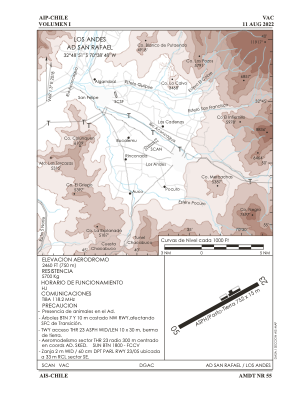
Coordinates: S32°48'51" W70°38'48"
Elevation is 2460 feet MSL.
Magnetic variation is 1° East View others Airports in Valparaíso
Operational data
Special qualification required
Current time UTC:
Current local time:
Weather at : SCEL - Arturo Merino Benitez ( 66 km )
METAR: SCEL 150100Z VRB01KT CAVOK 08/01 Q1014 NOSIG
TAF: TAF SCEL 142229Z 1500/1524 17006KT CAVOK TX11/1519Z TN03/1510Z BECMG 1502/1504 28004KT TEMPO 1508/1512 5000 HZ BECMG 1514/1516 16005KT SCT025 BKN170 BECMG 1516/1518 20010KT BECMG 1519/1521 SCT030 BKN060
Communications frequencies: [VIEW]
Runways:
| RWY identifier | QFU | Length (ft) | Width (ft) | Surface | LDA (ft) |
| 05 | 55° | 2465 | 46 | ASPH | |
| 23 | 235° | 2465 | 46 | ASPH |
Airport contact information
Address: Los Andes Chile
