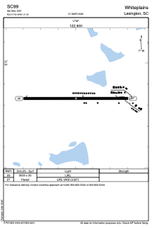


SC99 - Whiteplains
Located in Lexington, United States
ICAO - SC99, IATA -
Data provided by AirmateGeneral information
Coordinates: N33°57'50" W81°21'30"
Elevation is 525 feet MSL.
Magnetic variation is -05° East View others Airports in South Carolina
Operational data
Special qualification required
Current time UTC:
Current local time:
Weather at : KCAE - Columbia Metro ( 22 km )
METAR: KCAE 162256Z 00000KT 10SM FEW060 FEW200 28/17 A2980 RMK AO2 SLP087 T02830167
TAF: KCAE 162323Z 1700/1724 VRB03KT P6SM FEW200 FM171300 20005KT P6SM BKN150 FM172100 22006KT P6SM OVC100
Communications frequencies: [VIEW]
Runways:
| RWY identifier | QFU | Length (ft) | Width (ft) | Surface | LDA (ft) |
| 09 | 90° | 3000 | 35 | ASPH | |
| 27 | 270° | 3000 | 35 | ASPH |
Airport contact information
Address: Lexington United States