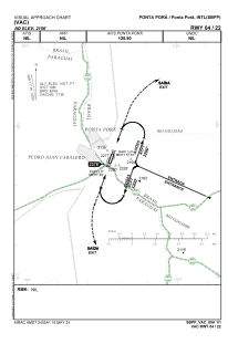
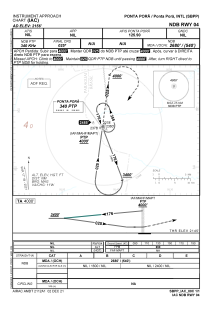
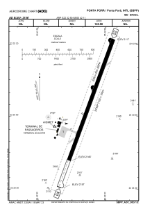


SBPP - Ponta Porã
Located in Ponta Porã, Brazil
ICAO - SBPP, IATA - PMG
Data provided by AirmateGeneral information
Coordinates: S22°32'59" W55°42'11"
Elevation is 2155 feet MSL.
Magnetic variation is -17.3° East View others Airports in Mato Grosso do Sul
Operational data
Special qualification required
Current time UTC:
Current local time:
Weather
TAF: TAF SBPP 170356Z 1706/1806 35010KT 9999 FEW020 TX27/1715Z TN18/1805Z BECMG 1710/1712 33015KT PROB30 1718/1721 27010KT FEW030TCU BECMG 1721/1723 23010KT BKN015 RMK PGE
Communications frequencies: [VIEW]
Runways:
| RWY identifier | QFU | Length (ft) | Width (ft) | Surface | LDA (ft) |
| 04 | 20° | 6955 | 492 | ASPH | |
| 22 | 200° | 6955 | 492 | ASPH |
Airport contact information
Address: Ponta Porã Brazil