

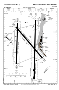


SBNT - Campo Augusto Severo
Located in Natal, Brazil
ICAO - SBNT, IATA - NAT
Data provided by AirmateGeneral information
Coordinates: S5°54'30" W35°14'57"
Elevation is 168 feet MSL.
Magnetic variation is -20.899087119° East View others Airports in Rio Grande do Norte
Operational data
Special qualification required
Current time UTC:
Current local time:
Weather
METAR: SBNT 092000Z 13011KT 9999 SCT023 29/24 Q1010
TAF: TAF SBNT 091415Z 0918/1006 14015KT 9999 SCT025 FEW035TCU TX29/0918Z TN26/1006Z BECMG 0921/0923 17012KT SCT025 BECMG 1001/1003 20007KT SCT020 RMK PGB
Communications frequencies: [VIEW]
Runways:
| RWY identifier | QFU | Length (ft) | Width (ft) | Surface | LDA (ft) |
| 12 | 99° | 6299 | 984 | ASPH | |
| 30 | 280° | 6299 | 984 | ASPH | |
| 16L | 140° | 9203 | 984 | ASPH | |
| 34R | 320° | 9203 | 984 | ASPH | |
| 16R | 141° | 6299 | 984 | ASPH | |
| 34L | 321° | 6299 | 984 | ASPH |
Airport contact information
Address: Natal Brazil