


S37 - Smoketown
Located in Smoketown, United States
ICAO - S37, IATA -
Data provided by AirmateGeneral information
Coordinates: N40°2'30" W76°12'7"
Elevation is 370 feet MSL.
Magnetic variation is -11° East View others Airports in Pennsylvania
Operational data
Special qualification required
Current time UTC:
Current local time:
Weather at : KLNS - Lancaster ( 12 km )
METAR: KLNS 081453Z 27011KT 10SM FEW027 25/20 A2964 RMK AO2 SLP032 T02500200 56010
TAF: KLNS 081516Z 0815/0912 27011G17KT P6SM SCT035 BKN150 FM081630 27014G24KT P6SM SCT045 SCT250 FM090000 28006KT P6SM BKN200 FM090900 34004KT P6SM BKN160 OVC200
Communications frequencies: [VIEW]
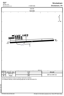
Runways:
| RWY identifier | QFU | Length (ft) | Width (ft) | Surface | LDA (ft) |
| 10 | 0° | 2750 | 50 | ASPH | |
| 28 | 0° | 2750 | 50 | ASPH |
Airport contact information
Address: Smoketown United States
