


S20 - Goldendale
Located in Goldendale, United States
ICAO - S20, IATA -
Data provided by AirmateGeneral information
Coordinates: N45°49'55" W120°50'43"
Elevation is 1678 feet MSL.
Magnetic variation is 19° East View others Airports in Washington
Operational data
Special qualification required
Current time UTC:
Current local time:
Weather at : KDLS - Columbia Gorge Rgnl/The Dalles Muni ( 34 km )
METAR: KDLS 211653Z AUTO 28008KT 10SM SCT060 BKN070 OVC085 14/04 A3010 RMK AO2 SLP190 T01440039
TAF: KDLS 211723Z 2118/2218 30015G25KT P6SM -RA OVC080 FM212200 30015G25KT P6SM -RA OVC050 FM220100 30012KT 6SM -RA OVC035 FM220700 30015G26KT P6SM OVC040
Communications frequencies: [VIEW]
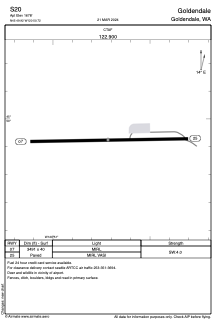
Runways:
| RWY identifier | QFU | Length (ft) | Width (ft) | Surface | LDA (ft) |
| 07 | 89° | 3491 | 40 | ASPH | |
| 25 | 269° | 3491 | 40 | ASPH |
Airport contact information
Address: Goldendale United States