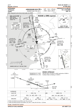
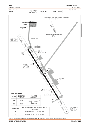


RKJK - Gunsan / Domestic
Located in Gunsan, Korea, Republic of
ICAO - RKJK, IATA - KUV
Data provided by AirmateGeneral information
Coordinates: N35°54'14" E126°36'57"
Elevation is 30 feet MSL.
Magnetic variation is -8° East View others Airports in Jeonrabugdo
Operational data
Special qualification required
Current time UTC:
Current local time:
Weather
METAR: RKJK 120655Z AUTO 32014KT 10SM CLR 20/10 A2983 RMK AO2 SLP106 T01950097 $
TAF: TAF RKJK 120000Z 1200/1306 35006KT 9000 HZ SCT150 QNH2983INS BECMG 1203/1204 32012KT 9000 HZ SKC 510033 QNH2986INS BECMG 1216/1217 33009KT 8000 BR SKC QNH2991INS BECMG 1302/1303 30006KT 9000 HZ FEW050 QNH2999INS TX22/1205Z TN11/1220Z
Communications frequencies: [VIEW]
Runways:
| RWY identifier | QFU | Length (ft) | Width (ft) | Surface | LDA (ft) |
| 18 | 169° | 9008 | 150 | CON | |
| 36 | 349° | 9008 | 150 | CON |
Airport contact information
Address: Gunsan Korea, Republic of