


RJTC - Tachikawa
Located in , Japan
ICAO - RJTC, IATA -
Data provided by AirmateGeneral information
Coordinates: N35°42'39" E139°24'11"
Elevation is 313 feet MSL.
View others Airports in Tokyo Prefecture
Operational data
Special qualification required
Current time UTC:
Current local time:
Weather
METAR: RJTC 212343Z 02005KT 310V060 9999 FEW030 SCT060 BKN230 20/08 Q1022 RMK 1CU030 4SC060 5CI230 A3018
Communications frequencies: [VIEW]
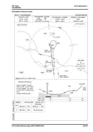
Runways:
| RWY identifier | QFU | Length (ft) | Width (ft) | Surface | LDA (ft) |
| 01 | 0° | 2953 | 148 | UNK | |
| 19 | 0° | 2953 | 148 | UNK |
Airport contact information
Address: Japan