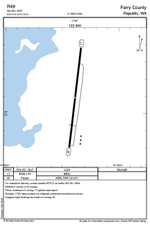


R49 - Ferry County
Located in Republic, United States
ICAO - R49, IATA -
Data provided by AirmateGeneral information
Coordinates: N48°43'6" W118°39'23"
Elevation is 2522 feet MSL.
Magnetic variation is 20° East View others Airports in Washington
Operational data
Special qualification required
Current time UTC:
Current local time:
Weather at : KOMK - Omak ( 69 km )
METAR: KOMK 211453Z AUTO 00000KT 10SM CLR 12/01 A2997 RMK AO2 SLP150 T01170006 58008
Communications frequencies: [VIEW]
Runways:
| RWY identifier | QFU | Length (ft) | Width (ft) | Surface | LDA (ft) |
| 17 | 0° | 3498 | 60 | ASPH | |
| 35 | 0° | 3498 | 60 | ASPH |
Airport contact information
Address: Republic United States