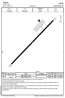


PHNY - Lanai
Located in Lanai City,
ICAO - LNY, IATA - LNY
Data provided by AirmateGeneral information
Coordinates: N20°47'8" W156°57'5"
Elevation is 1308 feet MSL.
Magnetic variation is 11° East View others Airports in Hawaii
Operational data
Special qualification required
Current time UTC:
Current local time:
Weather
METAR: PHNY 171256Z AUTO 17011G17KT 10SM BKN005 OVC010 22/21 A2994 RMK AO2 CIG 002V007 SLP118 T02170211
TAF: PHNY 171144Z 1712/1812 17014G20KT P6SM BKN003 OVC009 FM171800 20012KT P6SM SCT009 BKN015 FM180000 20009KT P6SM SCT012 BKN025 FM180600 06009KT P6SM SCT012 SCT025
Communications frequencies: [VIEW]
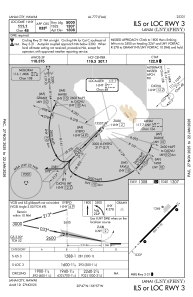
Runways:
| RWY identifier | QFU | Length (ft) | Width (ft) | Surface | LDA (ft) |
| 03 | 44° | 5001 | 150 | ASPH | 5000 |
| 21 | 224° | 5001 | 150 | ASPH | 5000 |
Airport contact information
Address: Lanai City