


PGUM - Guam Intl
Located in Guam, Guam
ICAO - GUM, IATA - GUM
Data provided by AirmateGeneral information
Coordinates: N13°29'2" E144°47'50"
Elevation is 305 feet MSL.
Magnetic variation is 02° East View others Airports in (unassigned)
Operational data
Special qualification required
Current time UTC:
Current local time:
Weather
METAR: PGUM 162154Z 08013G19KT 10SM SCT020 28/25 A2990 RMK AO2 SLP116 T02830250
TAF: PGUM 161722Z 1618/1724 07011KT P6SM VCSH FEW018 SCT030 FM170100 08013G23KT P6SM VCSH SCT018 BKN030 FM170900 07011KT P6SM VCSH FEW018 SCT030
Communications frequencies: [VIEW]
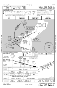
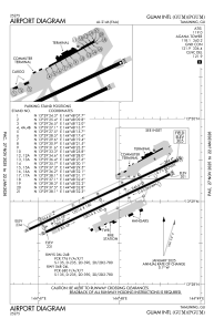
Runways:
| RWY identifier | QFU | Length (ft) | Width (ft) | Surface | LDA (ft) |
| 06L | 65° | 12014 | 150 | CONC+ASPH | 11014 |
| 24R | 245° | 12014 | 150 | CONC+ASPH | 12014 |
| 06R | 65° | 10014 | 150 | CONC+ASPH | 10014 |
| 24L | 245° | 10014 | 150 | CONC+ASPH | 8710 |
Airport contact information
Address: Guam Guam
