


P29 - Tombstone Muni
Located in Tombstone, United States
ICAO - P29, IATA -
Data provided by AirmateGeneral information
Coordinates: N31°40'17" W110°1'17"
Elevation is 4733 feet MSL.
Magnetic variation is 10° East View others Airports in Arizona
Operational data
Special qualification required
Current time UTC:
Current local time:
Weather at : KFHU - Sierra Vista Muni-Libby Aaf ( 32 km )
TAF: TAF KFHU 211200Z 2112/2218 VRB06KT 9999 FEW100 QNH2998INS BECMG 2117/2118 24012G18KT 9999 SKC 510005 QNH2994INS BECMG 2119/2120 25013G26KT 9999 SKC 520007 QNH2989INS BECMG 2200/2201 25009KT 9999 SKC 510005 QNH2990INS WND VRB06KT AFT 2211 BECMG 2215/2216 22010G16KT 9999 SKC 510005 QNH3001INS TX30/2121Z TN14/2112Z
Communications frequencies: [VIEW]
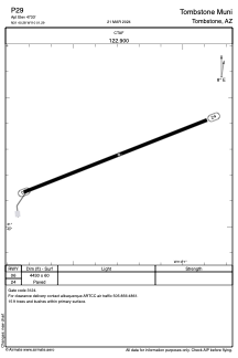
Runways:
| RWY identifier | QFU | Length (ft) | Width (ft) | Surface | LDA (ft) |
| 06 | 69° | 4430 | 60 | ASPH | |
| 24 | 249° | 4430 | 60 | ASPH |
Airport contact information
Address: Tombstone United States