


O24 - Lee Vining
Located in Lee Vining, United States
ICAO - O24, IATA -
Data provided by AirmateGeneral information
Coordinates: N37°57'28" W119°6'21"
Elevation is 6802 feet MSL.
Magnetic variation is 15° East View others Airports in California
Operational data
Special qualification required
Current time UTC:
Current local time:
Weather at : KMMH - Mammoth Yosemite ( 44 km )
METAR: KMMH 260815Z AUTO 33008KT 10SM SCT060 BKN100 05/M03 A2995 RMK AO2 T00511032
TAF: KMMH 260520Z 2606/2706 29016G22KT P6SM OVC100 FM261300 30016G30KT P6SM VCSH BKN050 OVC100 FM270400 33008KT P6SM SCT050 BKN100
Communications frequencies: [VIEW]
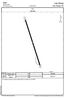
Runways:
| RWY identifier | QFU | Length (ft) | Width (ft) | Surface | LDA (ft) |
| 15 | 162° | 3920 | 60 | ASPH | |
| 33 | 342° | 3920 | 60 | ASPH |
Airport contact information
Address: Lee Vining United States