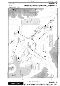
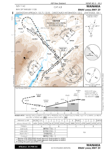


NZWF - Wanaka
Located in Wanaka, New Zealand
ICAO - NZWF, IATA - WKA
Data provided by AirmateGeneral information
Coordinates: S44°43'20" E169°14'44"
Elevation is 1142 feet MSL.
Magnetic variation is +24° East View others Airports in Otago Region
Operational data
Special qualification required
Current time UTC:
Current local time:
Weather at : NZQN - Queenstown ( 52 km )
METAR: NZQN 182230Z AUTO 04003KT 9999 NCD 03/M01 Q1018
TAF: TAF NZQN 181709Z 1818/1912 03005KT 9999 FEW070 BECMG 1900/1902 25010KT BECMG 1905/1907 03005KT
Communications frequencies: [VIEW]
Runways:
| RWY identifier | QFU | Length (ft) | Width (ft) | Surface | LDA (ft) |
| 11 | 139° | 3937 | 98 | BITUM | 3937 |
| 29 GR | 0° | 2953 | 197 | GRASS | |
| 29 | 319° | 3937 | 98 | BITUM | 3937 |
| 11G | 0° | 0 | 0 | UNK | 2953 |
| 29G | 0° | 0 | 0 | UNK | 2953 |
Airport contact information
Address: Wanaka New Zealand
