


NR32 - Holly Ridge/Topsail Island
Located in Holly Ridge, United States
ICAO - NR32, IATA -
Data provided by AirmateGeneral information
Coordinates: N34°29'26" W77°31'56"
Elevation is 49 feet MSL.
Magnetic variation is -08° East View others Airports in North Carolina
Operational data
Special qualification required
Current time UTC:
Current local time:
Weather at : KNCA - New River Mcas (Mccutcheon Fld) ( 26 km )
METAR: KNCA 191326Z AUTO 03009KT 10SM OVC006 17/17 A2995 RMK AO2 T01670167 $
TAF: TAF KNCA 1909/2009 02010KT 9999 BKN025 BKN035 522409 523308 641209 642104 QNH2986INS TEMPO 1909/1914 4800 -RA BR OVC005 BECMG 1917/1919 03012KT 9999 SCT030 500000 600000 QNH2990INS TEMPO 1917/1923 04012G22KT T17/1912Z T22/1920Z
Communications frequencies: [VIEW]
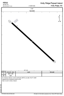
Runways:
| RWY identifier | QFU | Length (ft) | Width (ft) | Surface | LDA (ft) |
| 14 | 132° | 3591 | 88 | GRASS | |
| 32 | 312° | 3591 | 88 | GRASS |
Airport contact information
Address: Holly Ridge United States