


NR32 - Holly Ridge/Topsail Island
Located in Holly Ridge, United States
ICAO - NR32, IATA -
Data provided by AirmateGeneral information
Coordinates: N34°29'26" W77°31'56"
Elevation is 49 feet MSL.
Magnetic variation is -08° East View others Airports in North Carolina
Operational data
Special qualification required
Current time UTC:
Current local time:
Communications frequencies: [VIEW]
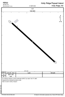
Runways:
| RWY identifier | QFU | Length (ft) | Width (ft) | Surface | LDA (ft) |
| 14 | 132° | 3591 | 88 | GRASS | |
| 32 | 312° | 3591 | 88 | GRASS |
Airport contact information
Address: Holly Ridge United States