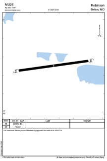


MU26 - Robinson
Located in Belton, United States
ICAO - MU26, IATA -
Data provided by AirmateGeneral information
Coordinates: N38°46'15" W94°33'32"
Elevation is 1087 feet MSL.
Magnetic variation is 04° East View others Airports in Missouri
Operational data
Special qualification required
Current time UTC:
Current local time:
Weather at : KOJC - Johnson County Exec ( 18 km )
METAR: KOJC 221453Z 34007KT 10SM BKN100 BKN120 18/08 A2996 RMK AO2 SLP138 T01780083 53005
Communications frequencies: [VIEW]
Runways:
| RWY identifier | QFU | Length (ft) | Width (ft) | Surface | LDA (ft) |
| 08 | 0° | 2260 | 30 | ASPH | |
| 26 | 0° | 2260 | 30 | ASPH |
Airport contact information
Address: Belton United States