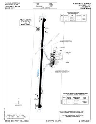


MMAS - Aguascalientes Aeropuerto Internacional Jesus Teran
Located in Aguascalientes, Mexico
ICAO - MMAS, IATA - AGU
Data provided by AirmateGeneral information
Coordinates: N21°42'20" W102°19'4"
Elevation is 6112 feet MSL.
View others Airports in Aguascalientes
Operational data
Special qualification required
Current time UTC:
Current local time:
Weather
METAR: MMAS 172040Z 22018KT 10SM SKC 33/M11 A3005
TAF: TAF MMAS 171633Z 1718/1818 24010KT P6SM SKC BECMG 1721/1722 24015KT FM180400 24008KT P6SM SKC FM181800 23010KT P6SM SKC
Communications frequencies: [VIEW]
Runways:
| RWY identifier | QFU | Length (ft) | Width (ft) | Surface | LDA (ft) |
| 18 | 183° | 9862 | 148 | UNK | |
| 36 | 3° | 9862 | 148 | UNK |
Airport contact information
Address: Aguascalientes Mexico