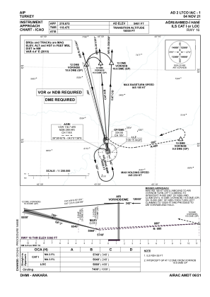


LTCO - Agri Ahmed-I Hani
Located in Agri, Turkey
ICAO - LTCO, IATA - AJI
Data provided by AirmateGeneral information
Coordinates: N39°38'51" E43°1'43"
Elevation is 5461 feet MSL.
Magnetic variation is 6.0° East View others Airports in Agri
Operational data
Special qualification required
Current time UTC:
Current local time:
Weather
METAR: LTCO 090850Z 27007KT 220V310 9999 SCT040 15/02 Q1021
TAF: TAF LTCO 090740Z 0909/0918 VRB02KT 9999 SCT040 BECMG 0909/0912 24012KT
Communications frequencies: [VIEW]
Runways:
| RWY identifier | QFU | Length (ft) | Width (ft) | Surface | LDA (ft) |
| 16 | 165° | 9843 | 148 | CONC | 9843 |
| 34 | 345° | 9843 | 148 | CONC | 9843 |
Airport contact information
Address: Agri Turkey