


LTAH - Afyon
Located in Afyon, Turkey
ICAO - LTAH, IATA - AFY
Data provided by AirmateGeneral information
Coordinates: N38°43'33" E30°36'11"
Elevation is 3310 feet MSL.
Magnetic variation is 5.64° East View others Airports in Afyonkarahisar
Operational data
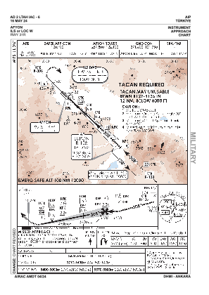
Special qualification required
Current time UTC:
Current local time:
Weather
TAF: TAF LTAH 261040Z 2612/2621 VRB02KT 9999 FEW030 BKN200 BECMG 2612/2614 14012KT -TSRA FEW020CB BKN030 TEMPO 2615/2618 TSRA
Communications frequencies: [VIEW]
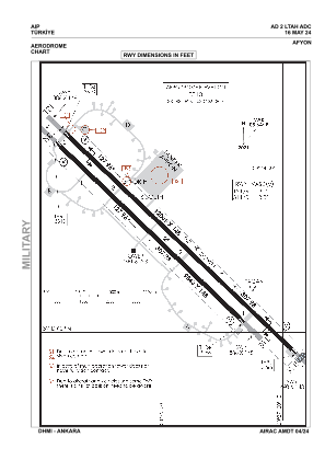
Runways:
| RWY identifier | QFU | Length (ft) | Width (ft) | Surface | LDA (ft) |
| 13R | 134° | 9843 | 148 | CONC | 9843 |
| 31L | 314° | 9843 | 148 | CONC | 9843 |
| 13L | 134° | 12005 | 148 | CONC | 12005 |
| 31R | 314° | 12005 | 148 | CONC | 12005 |
Airport contact information
Address: Afyon Turkey