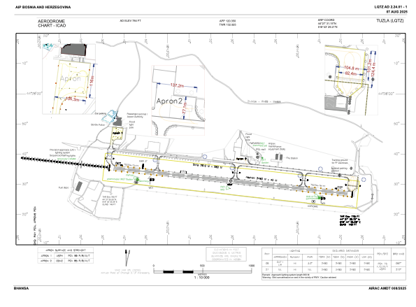


LQTZ - International Airport Tuzla
Located in Tuzla, Bosnia and Herzegovina
ICAO - LQTZ, IATA - TZL
Data provided by AirmateGeneral information
Coordinates: N44°27'31" E18°43'29"
Elevation is 784 feet MSL.
Magnetic variation is 005° East View others Airports in Federacija Bosna i Hercegovina
Operational data
Special qualification required
Current time UTC:
Current local time:
Weather
METAR: LQTZ 182100Z VRB01KT CAVOK 15/14 Q1012
TAF: TAF LQTZ 181700Z 1818/1918 VRB02KT CAVOK TX27/1914Z TN12/1904Z PROB40 TEMPO 1912/1918 12012KT 4000 TSRA FEW035CB BKN045
Communications frequencies: [VIEW]
Runways:
| RWY identifier | QFU | Length (ft) | Width (ft) | Surface | LDA (ft) |
| 09 | 96° | 8169 | 148 | ASP | 8169 |
| 27 | 276° | 8169 | 148 | ASP | 8169 |
Airport contact information
Address: Tuzla Bosnia and Herzegovina