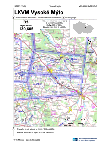


LKVM - Vysoke Myto
Located in Vysoke Myto, Czech Republic
ICAO - LKVM, IATA -
Data provided by AirmateGeneral information
Coordinates: N49°55'37" E16°11'9"
Elevation is 988 feet MSL.
View others Airports in Pardubice Region
Operational data
Special qualification required
Current time UTC:
Current local time:
Weather at : LKPD - Pardubice ( 33 km )
METAR: LKPD 161200Z 14017KT 110V180 CAVOK 20/08 Q1012 NOSIG RMK BLU BLU
TAF: TAF LKPD 161100Z 1612/1712 13017KT CAVOK TEMPO 1612/1615 14020G30KT PROB30 TEMPO 1613/1620 SHRA SCT040 PROB40 TEMPO 1615/1618 14015G25KT BECMG 1620/1622 12014KT BECMG 1706/1709 7000 RA BKN025 TEMPO 1708/1712 4000 RA BKN014
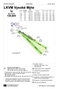
Communications frequencies: [VIEW]
Runways:
| RWY identifier | QFU | Length (ft) | Width (ft) | Surface | LDA (ft) |
| 12L | 0° | 1969 | 59 | UNK | |
| 30R | 0° | 1969 | 59 | UNK | |
| 14 | 0° | 3281 | 262 | UNK | |
| 32 | 0° | 3281 | 262 | UNK | |
| 12R | 0° | 3937 | 131 | UNK | |
| 30L | 0° | 3937 | 131 | UNK |
Airport contact information
Address: Vysoke Myto Czech Republic
