


LHVE - Veresegyhaz
Located in Veresegyhaza, Hungary
ICAO - , IATA -
Data provided by AirmateGeneral information
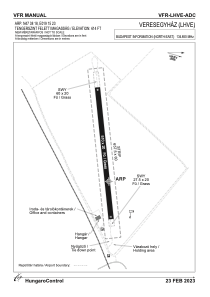
Coordinates: N47°38'18" E19°15'23"
Elevation is 614 feet MSL.
View others Airports in Pest
Operational data
Special qualification required
Current time UTC:
Current local time:
Weather at : LHBP - Budapest/Liszt Ferenc International Airport ( 22 km )
METAR: LHBP 142200Z 08006KT CAVOK 16/02 Q1014 NOSIG
TAF: TAF LHBP 141715Z 1418/1518 05005KT CAVOK TEMPO 1420/1503 11011KT BECMG 1507/1510 13009KT TEMPO 1510/1518 VRB18G30KT 4500 SHRA TSRA SCT055CB BKN070
Communications frequencies: [VIEW]
Runways:
| RWY identifier | QFU | Length (ft) | Width (ft) | Surface | LDA (ft) |
| 08 | 0° | 1673 | 66 | GRASS | |
| 26 | 0° | 1673 | 66 | GRASS |
Airport contact information
Address: Veresegyhaza Hungary