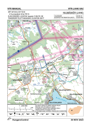
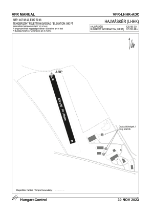


LHHK - Hajmasker
Located in Hajmasker, Hungary
ICAO - , IATA -
Data provided by AirmateGeneral information
Coordinates: N47°8'42" E17°59'46"
Elevation is 584 feet MSL.
View others Airports in Veszprém
Operational data
Special qualification required
Current time UTC:
Current local time:
Weather at : LHPA - Papa ( 45 km )
METAR: LHPA 240945Z VRB03KT 9999 SCT026TCU SCT200 22/15 Q1018 NOSIG RMK BLU
TAF: TAF LHPA 240515Z 2406/2506 VRB03KT CAVOK PROB40 TEMPO 2406/2418 VRB14G25KT 6000 SHRA TSRA SCT040CB BKN050TCU BECMG 2409/2412 19008KT BECMG 2415/2418 14006KT
Communications frequencies: [VIEW]
Runways:
| RWY identifier | QFU | Length (ft) | Width (ft) | Surface | LDA (ft) |
| 16 | 0° | 1427 | 164 | GRASS | |
| 34 | 0° | 1427 | 164 | GRASS |
Airport contact information
Address: Hajmasker Hungary