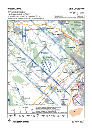
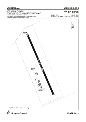


LHGR - Gyuro
Located in Gyuro, Hungary
ICAO - LHGR, IATA -
Data provided by AirmateGeneral information
Coordinates: N47°23'40" E18°45'19"
Elevation is 640 feet MSL.
View others Airports in Fejér
Operational data
Special qualification required
Current time UTC:
Current local time:
Weather at : LHBP - Budapest/Liszt Ferenc International Airport ( 38 km )
METAR: LHBP 280300Z 04003KT 010V080 CAVOK 14/07 Q1016 NOSIG
TAF: TAF LHBP 272315Z 2800/2824 10005KT CAVOK TEMPO 2800/2806 34003KT TEMPO 2809/2812 16005KT BECMG 2812/2815 32005KT TEMPO 2812/2819 FEW070TCU SCT080 TEMPO 2816/2820 35013G23KT
Communications frequencies: [VIEW]
Runways:
| RWY identifier | QFU | Length (ft) | Width (ft) | Surface | LDA (ft) |
| 15 | 0° | 2461 | 66 | GRASS | |
| 33 | 0° | 2461 | 66 | GRASS |
Airport contact information
Address: Gyuro Hungary