


LHBL - Balloszog
Located in Balloszog, Hungary
ICAO - , IATA -
Data provided by AirmateGeneral information
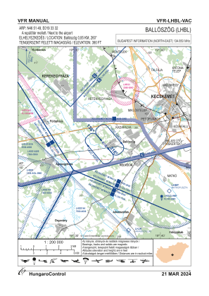
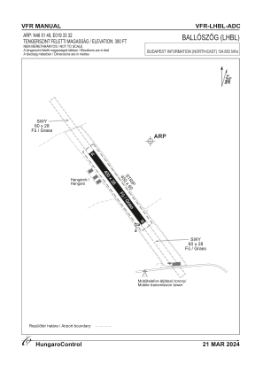
Coordinates: N46°51'49" E19°33'32"
Elevation is 390 feet MSL.
Magnetic variation is 5° East View others Airports in Bács-Kiskun
Operational data
Special qualification required
Current time UTC:
Current local time:
Weather at : LHKE - Kecskemet ( 16 km )
METAR: LHKE 241315Z VRB02KT 9999 SCT020 BKN100 21/16 Q1019 NOSIG RMK BLU
TAF: TAF LHKE 241115Z 2412/2421 VRB03KT 9999 FEW018 SCT040 BKN100 TEMPO 2412/2418 15006KT 8000 -SHRA FEW015 SCT033TCU BKN070 PROB30 TEMPO 2413/2417 VRB10G20KT 5000 SHRA TSRA SCT012 SCT025CB BKN050 BECMG 2417/2419 CAVOK
Communications frequencies: [VIEW]
Runways:
| RWY identifier | QFU | Length (ft) | Width (ft) | Surface | LDA (ft) |
| 14 | 144° | 1061 | 74 | GRASS | |
| 32 | 324° | 1061 | 74 | GRASS |
Airport contact information
Address: Balloszog Hungary