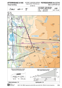


LFIP - Peyresourde Balestas
Located in , France
ICAO - LFIP, IATA -
Data provided by AirmateGeneral information
Coordinates: N42°47'49" E0°26'2"
Elevation is 5193 feet MSL.
Magnetic variation is 0.74° East View others Airports in Midi-Pyrénées
Operational data
Special qualification required
Current time UTC:
Current local time:
Weather at : LFBT - Tarbes Lourdes Pyrenees ( 56 km )
METAR: LFBT 161330Z AUTO 31003KT 230V010 9999 FEW045 SCT052 BKN062 16/09 Q1008 TEMPO VRB15G25KT -TSRA SCT020CB BKN025TCU
TAF: TAF LFBT 161100Z 1612/1712 VRB03KT 9999 FEW035 BKN060 BKN200 TEMPO 1612/1621 FEW035CB PROB40 TEMPO 1612/1620 -SHRA BKN040TCU PROB30 TEMPO 1615/1618 VRB15G25KT -TSRA SCT020CB BKN025TCU FM162100 VRB03KT CAVOK
Communications frequencies: [VIEW]
Runways:
| RWY identifier | QFU | Length (ft) | Width (ft) | Surface | LDA (ft) |
| 09 | 94° | 1542 | 66 | ASPH | |
| 27 | 274° | 1542 | 66 | ASPH |
Airport contact information
Address: France
