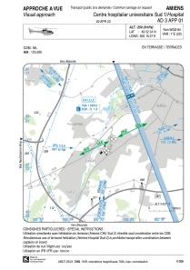


LFH439 - Amiens Centre Hospitalier Universitaire Sud 1
Located in , France
ICAO - , IATA -
Data provided by AirmateGeneral information
Coordinates: N49°52'34" E2°15'27"
Elevation is 250 feet MSL.
View others Airports in Picardie
Operational data
Special qualification required
Current time UTC:
Current local time:
Weather at : LFAQ - Albert Bray ( 33 km )
METAR: LFAQ 160600Z AUTO 24009KT 9999 -RA FEW004/// BKN041/// BKN052/// ///CB 12/12 Q1004 TEMPO 2000 RA BKN002 OVC014 BKN020CB
TAF: TAF LFAQ 160500Z 1606/1615 22005KT 6000 BKN030 TEMPO 1606/1610 2000 RA BKN002 OVC014 BKN020CB TEMPO 1610/1615 4000 SHRA BKN014 BKN020CB
Communications frequencies: [VIEW]
Runways:
Airport contact information
Address: France