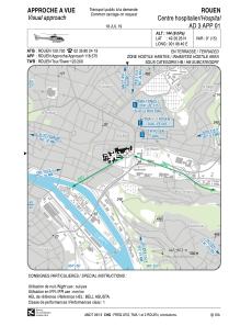


LFH179 - Rouen Centre Hospitalier
Located in , France
ICAO - , IATA -
Data provided by AirmateGeneral information
Coordinates: N49°26'26" E1°6'40"
Elevation is 144 feet MSL.
Magnetic variation is 0.61° East View others Airports in Upper Normandy
Operational data
Special qualification required
Current time UTC:
Current local time:
Weather at : LFOP - Rouen Vallee De Seine ( 8 km )
METAR: LFOP 111500Z AUTO 08008KT 060V130 7000 NSC 24/11 Q1017 NOSIG
TAF: TAF LFOP 111400Z 1115/1124 09010KT CAVOK
Communications frequencies: [VIEW]
Runways:
Airport contact information
Address: France